Location: Springbrook National Park, Gold Coast QLD, Australia
Run Type: Trail | singletrack, firetrail, stairs, rocky, steep climbing, forest, scenic, creek crossings
Distance: 9.6km return from Apple Tree Park to Chesters Rd; ~ 14km return to Numinbah Village
Total Elevation Gain: 550m (from Apple Tree Park to Chesters Rd return)
Trail Map: To view at full size and/or print; click on the image to open the map, then right click and select 'save image as'. Open the map from the save location to view at full size.
GPS Link: http://connect.garmin.com/course/3370638
Description: A descent following more than 900 steps and steep singletrack down into the valley before a testing climb back up and out to Chesters Rd. This run forms a section of the Gold Coast Hinterland Great Walk, and for our Adventure we run it as an out-and-back, meaning that what starts out as a descent of countless steps, soon becomes a challenging climb back out! Directions are from Apple Tree Park heading towards Numinbah Village, although the run is just as achievable starting from the other end.
Starting from Apple Tree park, head away from the road on the well defined trail. There are a few tracks branching off from the trail in the first 500m or so but you always want to stay on the main trail, which will be signposted with a "Great Walk" arrow. These arrows will be seen several times during your run, and if you're ever in doubt as to where to go simply keep an eye out for the arrow posts and you shouldn't have too many troubles.
After the first flat 500m you will reach some well formed stairs leading down into the valley.
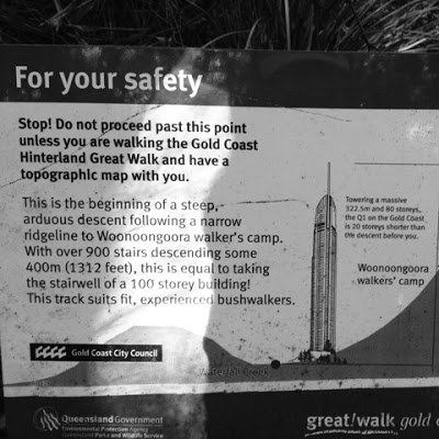
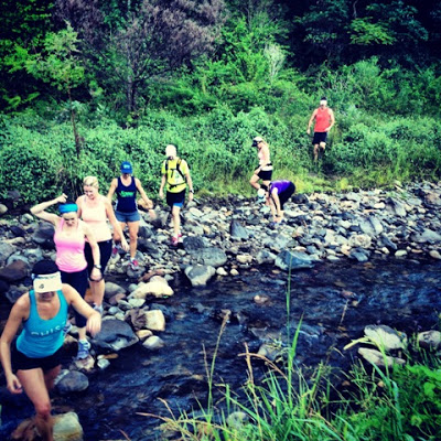
It's a steep descent from here (over 900 steps!) down to the Woonoongoora walkers camp. From the walkers camp you again follow the arrow signposts which take you further downhill along firetrails towards Waterfall Creek. You will cross Waterfall Creek twice in relatively quick succession before you skirt farmland and come out at a well maintained gravel firetrail heading up and out of the valley. Following this firetrail (and, again, following the arrow markers) you will eventually come out at the end of Chester's Rd.
If you head down Chesters Rd a short way you will quickly come to track step-through gates on both sides of the road (these gates give you access to the Waterfall Creek Circuit, a map of which can be found on one of our earlier posts here). These particular gates give access to the "Long Loop" shown on the Waterfall Creek map; alternatively you can continue down Chesters Rd until you come to another gate on your left, which is the gate to the "Short Loop" on the Waterfall Creek map. Either way, taking the left trails off Chesters Rd will take you down towards Numinbah Village, although the lower trail (the "Short Loop" gate from the Waterfall Creek map) is the "official" Great Walk track and is signposted as such.
For the GPS track link above we turned around on Chesters Rd and simply retraced our steps back to Apple Tree Park, including the 900 or so steps! For the keen, the run into Numinbah Village is nice and involves a fast descent, meaning you can add further climbing on the return journey of the out-and-back run.
The National Parks folks advise that all runners/walkers carry a Great Walks topographic map of the area, and this is wise advice. My additional advice is simply to watch out for the arrow signposts which are quite regular and usually obvious (assuming you are still on course!). If you follow the arrows and keep to the main trails you shouldn't run into too many problems.
After the first flat 500m you will reach some well formed stairs leading down into the valley.
It's a steep descent from here (over 900 steps!) down to the Woonoongoora walkers camp. From the walkers camp you again follow the arrow signposts which take you further downhill along firetrails towards Waterfall Creek. You will cross Waterfall Creek twice in relatively quick succession before you skirt farmland and come out at a well maintained gravel firetrail heading up and out of the valley. Following this firetrail (and, again, following the arrow markers) you will eventually come out at the end of Chester's Rd.
If you head down Chesters Rd a short way you will quickly come to track step-through gates on both sides of the road (these gates give you access to the Waterfall Creek Circuit, a map of which can be found on one of our earlier posts here). These particular gates give access to the "Long Loop" shown on the Waterfall Creek map; alternatively you can continue down Chesters Rd until you come to another gate on your left, which is the gate to the "Short Loop" on the Waterfall Creek map. Either way, taking the left trails off Chesters Rd will take you down towards Numinbah Village, although the lower trail (the "Short Loop" gate from the Waterfall Creek map) is the "official" Great Walk track and is signposted as such.
For the GPS track link above we turned around on Chesters Rd and simply retraced our steps back to Apple Tree Park, including the 900 or so steps! For the keen, the run into Numinbah Village is nice and involves a fast descent, meaning you can add further climbing on the return journey of the out-and-back run.
The National Parks folks advise that all runners/walkers carry a Great Walks topographic map of the area, and this is wise advice. My additional advice is simply to watch out for the arrow signposts which are quite regular and usually obvious (assuming you are still on course!). If you follow the arrows and keep to the main trails you shouldn't run into too many problems.
This is a run that involves sustained climbing, but it's fun and covers some beautiful scenery if you lift your head long enough to take a look. It's also a great leg workout climbing the stairs and it sure beats using the stepper in a gym. Get outdoors and get dirty!
See you out there!